PART 2 of 2: County Trail Planners in a Hurry to Find Path of Least Resistance
Thursday, June 20, 2024
by Jeff Noedel
Video editing by Jeremy Tyler
A CNL2 VIDEO IS AT THE BOTTOM OF THIS PAGE
Landowners in the proposed pathway of a new trail to Zylstra Lake are a “hard no.”
Again.
San Juan County is running low on time to negotiate easements for a foot and bike path which surveys suggest 82 percent of San Juan Countians want.
More trails (and wider roads) aren’t a new desire here. A study released by the County 19 years ago found, “The County’s Parks and Recreation Plan (2005) identifies trails and bikeways as a critical issue. A survey of 5,000 random households discovered that 82 percent of county residents “agreed” or “strongly agreed” that “trails and bikeways should be an integral part of transportation planning for the county.”
If you’re a fan of more recent data: “A 2023 Public Works survey with approximately 1,000 respondents found:
- 86 percent expressed desire for enhanced road shoulders, separated trails, or both, while only 8 percent favor no non-motorized infrastructure improvements
- 70 percent in favor of “increased programmatic prioritization and direct funding for trails and non-motorized transportation corridors”
- The top road concern is “congested roads (bikes, pedestrians, etc.)
In February 2021, Congressman Rick Larsen called for ideas for local grants; the next month San Juan County developed the idea of a trail to Zylstra Lake. The month after that, the County and Town of Friday Harbor Councils passed resolutions in support of the idea.
A year and a half later, Larsen won $5.28 million for a trail on San Juan Island, indicating that landing Federal funds for special projects can involve a lot of work for a Member of Congress.
The legislation that granted the millions of dollars has conditions, as all grants do:
- the trail must connect Friday Harbor to some sort of a destination, referred to by the planners as “a place of interest” (a lake, a landmark, or even a major housing subdivision)
- if the trail is adjacent to a road, the trail must be separated from that road, at least by a fence or hedge; it cannot be on the shoulder of a road
- funds for the project must be fully allocated by Autumn 2026, or the grant expires and the money goes away
In a public meeting on Wednesday, June 5, landowners asked County officials if Congress might be willing to modify the terms of the grant to allow the money to be used for shoulder widening instead, or if the deadline could be extended. County Council District 1 Representative Christine Minney and other staff said that isn’t possible because it would require another act of the U.S. Congress. If the county is to get a new $5 million trail, the County must stay within the contours of the grant, including the time boundaries of the grant.
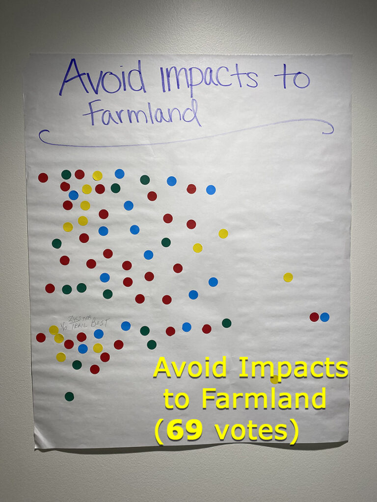
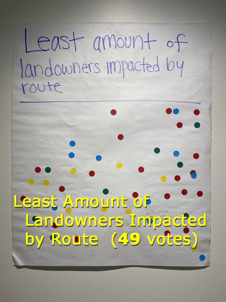
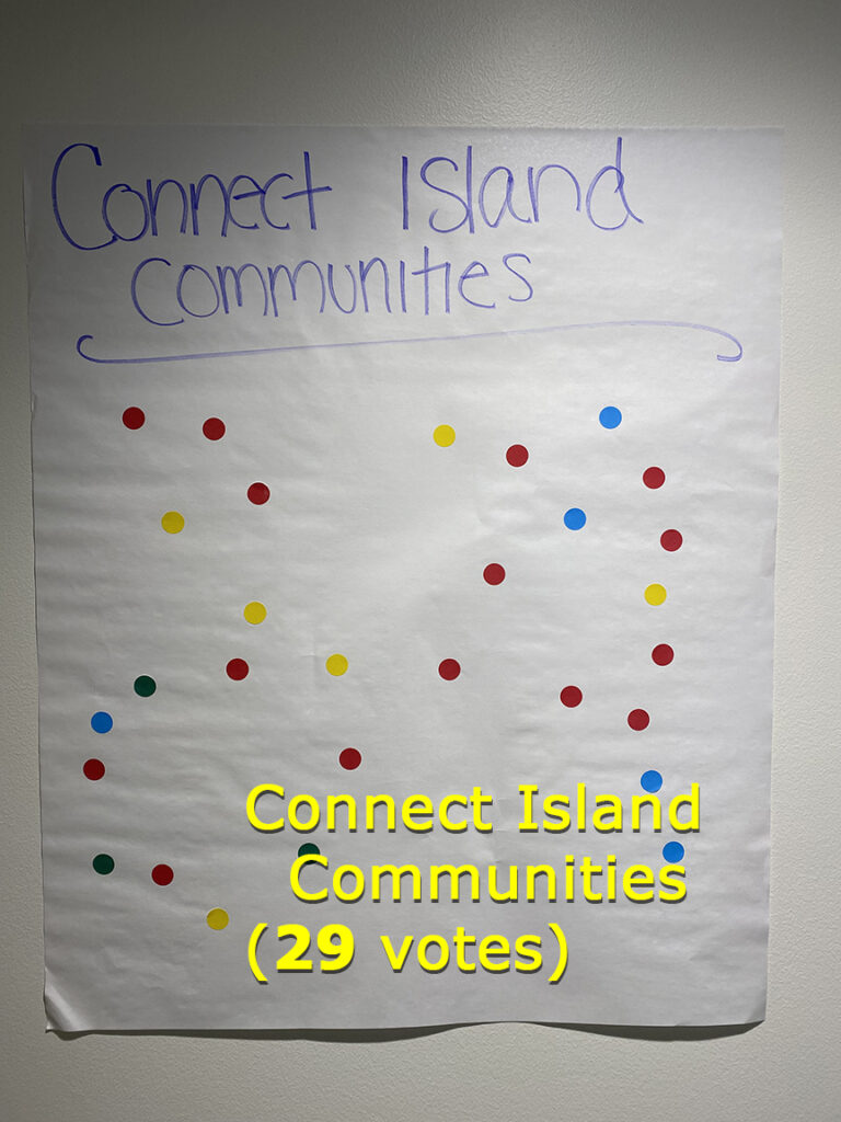
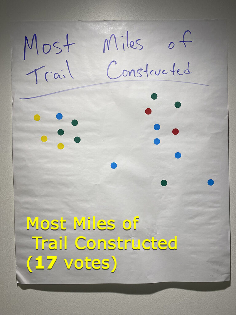
As an ice-breaker, and in an effort to gauge the priorities of land owners relating to the idea of a trail through their neighborhood, the County had taped eight large white sheets of paper on the west wall of the meeting room, each with a title across the top. Participants were given two stickers and asked to put a sticker under the two headlines most important to them. They were told they could use both stickers on one poster if they chose.
The eight posters were labeled:
- Avoid impacts to farmland (received 69 stickers, or “votes”)
- Least amount of landowners impacted by route (49 votes)
- Connect island communities (29)
- Most miles of trail constructed (17)
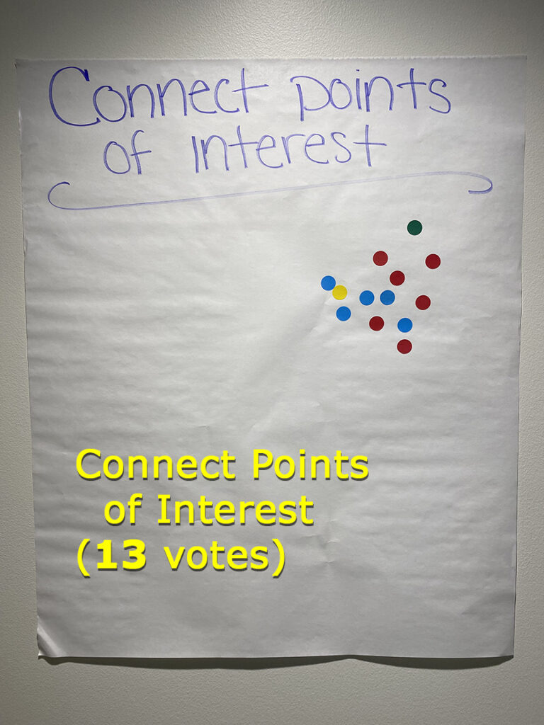
- Connect points of interest (13)
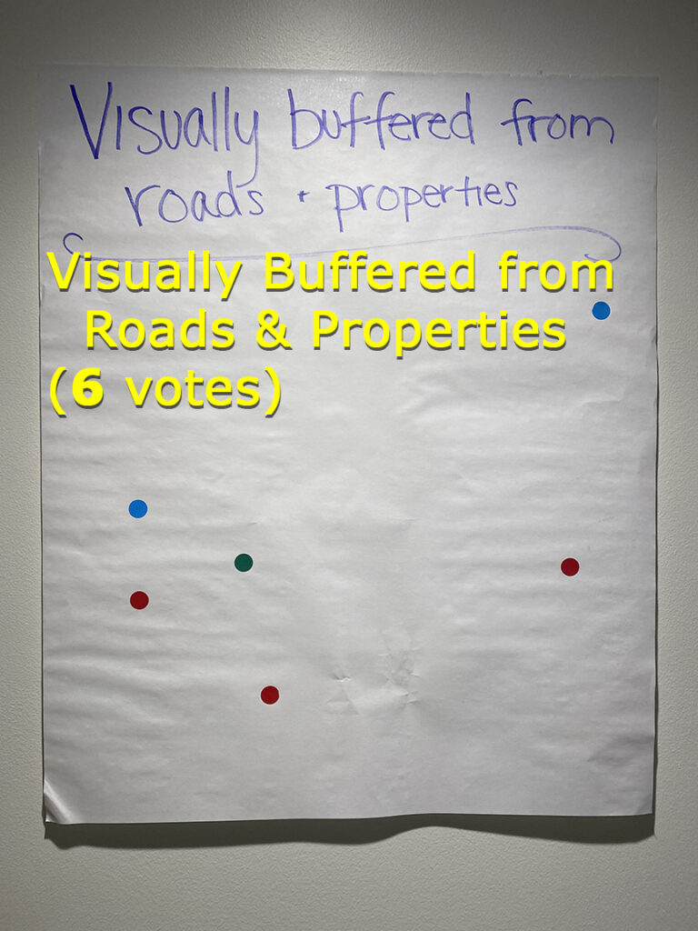
- Visually buffered from roads and properties (6)
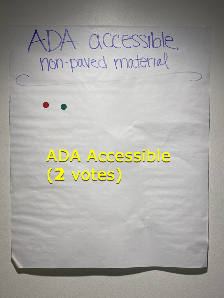
- ADA accessible (2)
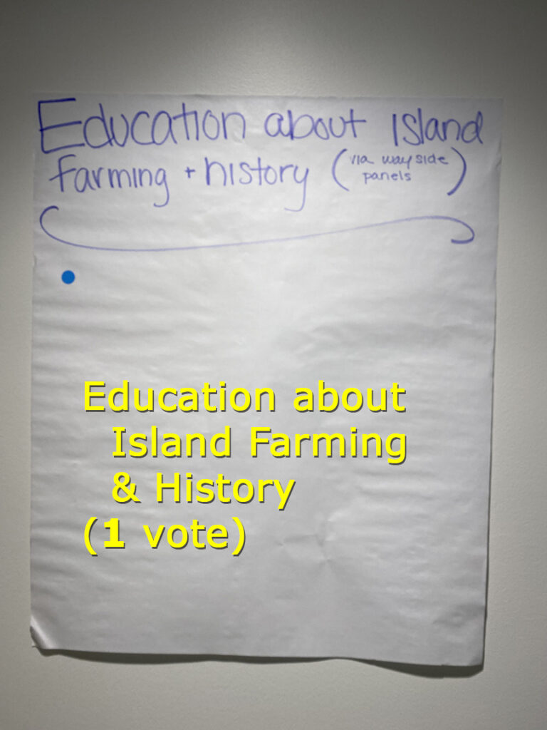
- Education about island farming & history (1)
County officials readily admitted to the approximately 125 souls assembled for the 90-minute meeting in the Marie Boe Building on the Fairgrounds, as well as directly to CNL2 in interviews, that the County has moved too slowly on this project. Reasons vary, but range from possible misunderstandings as to which County Department was supposed to be advancing the trail project, to indecisiveness in the County Manager’s Office, to too many direct reports to the County Manager in the County’s table of organization.
Council Rep. Minney summed it up in a CNL2 on-camera interview moments after the meeting adjourned, “I am very happy with the staff, always. I think they took a little bit of heat today for a circumstance that none of us have ever navigated before. And we may have — in hindsight — made missteps, but we’re learning at the same time.”
The 90-minute public meeting was moderated by Brandon Andrews, Parks & Fair Director and Interim Assistant County Manager. It began with a presentation by Grant Carlton, Policy & Regional Initiatives Manager. Additional comments were delivered by Colin Huntemer, Director of Public Works. Christine Minney stood in the front of the room with Andrews, Carlton, and Huntemer, facing the crowd. Erin Andrews, the County’s Communications Coordinator, assisted in preparing for the meeting.
Minney was one of just four or five people in the room whose remarks indicated they supported the idea of a trail through San Juan Valley. The overwhelming majority were opposed.
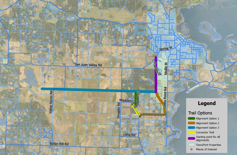
From the moment people were taking their seats for the meeting, a video projector beamed a map of central San Juan Island onto the beige east wall in the room. The map featured five “mix and match” sections of trail (“alignments” in planner speak), each signified by a different color.
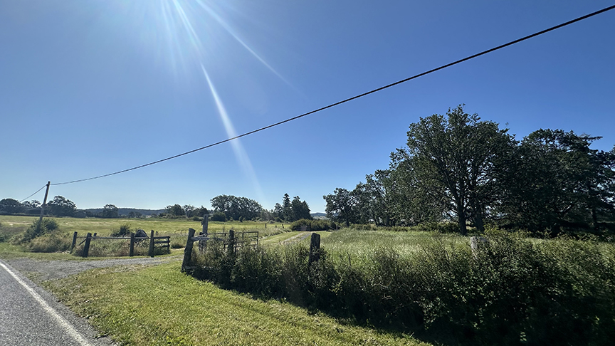
A common denominator in any chosen trail is the “purple route” that begins in Friday Harbor at the intersection of Spring St. and Franklin Drive and then Weber Way (the roads that run between the airport and the back of the hospital) southward along the edge of the Port Authority property until it gets to a lightly wooded area almost lateral to the southern end of the airport runway.
The County had been focused on the route to Zylstra Lake, which was labeled the “teal route” in the planners’ map. A previous County proposal would have had the trail run parallel to San Juan Valley Rd., but that route met stiff opposition by land owners in November 2023. This Spring, the County proposed a different route to Zylstra, cutting in a different path along property edges approximately 1/2 mile south, and parallel to, San Juan Valley Rd. This was the “teal route”
The teal route would be mentioned many times in the meeting.
A CNL2 VIDEO IS AT THE BOTTOM OF THIS PAGE
Opposition, spearheaded by a next-door neighbor to Zylstra Lake, Ron Whalen, was locked and loaded before the meeting started.
The meeting began with a PowerPoint by Grant Carlton, but some in audience were anxious for Q&A to start. About 20 minutes his presentation, Carlton asked, “Am I talking too fast?”
“You’re talking too slow,” a man shouted.
“Too much,” another man shouted, sparking some laughter in the audience and looks of concern on faces of County officials.
The assembled citizens were extremely alert, and the room was full of intensity. The meeting was peppered with raised voices, some shouting, groans, boos, and at one point, raspberries. Most citizens commented from their chairs or stood up by their chairs. One of two citizens who walked to the front of the room to speak used coarse language, but those particular comments drew more muted, limited applause.
Carlton powered through the PowerPoint and then the County fielded 29 questions and statements from the residents until the scheduled end of meeting. County officials did not want to cut off comments until the session reached the promised 90-minute mark. At the strike of 6:00 p.m., the meeting ended, along apparently with the teal route.
Questions and comments included:
- Can the grant be rewritten? (answer: no)
- Where will extra money to build the trail come from when the $5 million runs out? (answer: the project will be built within the $5.28 million Federal appropriation)
- How will the County protect private land adjacent to the trail from risks associated with a trail, such as trespassing, use of fireworks, etc.? (answer: this is a risk for all trails; “We can’t allow fear to drive us away from doing something good”)
- I have teens who walk and bike the roads, which are absolutely frightening (5 hands went up in agreement)
- How will the County pay for up keep of the trail (answer: there is currently ample budget and capacity for trail maintenance)
- Can’t you just put shoulders on San Juan Valley Rd., in the 3- to 5-foot easements in existence? (answer: the grant wasn’t intended or written for that purpose)
- In the planning period when Federal funds have not yet been allocated, are County taxpayers fronting the planning costs until those costs are reimbursed by the Federal money? (answer: yes)
- The trail is more about recreation than transportation. Why are local taxpayers paying for a project for visitors? (answer: the project is mainly intended for local residents; it will be ultimately paid for with Federal money)
- Will you use eminent domain to take our property? (Rep. Minney answered “no” for herself, but indicated she is but one of three Council Representatives)
- This trail would be beneficial to me and my family.
- I’m disappointed in the process. I feel blindsided. You didn’t visit me or my property.
- Not one single property owner was consulted (answer: the County has visited with multiple property owners in the proposed “teal route”)
- Since the “teal route” is not adjacent to a roadway, it would not be conducive to hopping on and hopping off.
- You want to take people’s lands (answer: The County is seeking easements, which is not the same as eminent domain)
- You’ve already spent $200,000 to $300,000 on the project. I forgive you. Just stop, forget about the Federal money, and fix our roads.
- The “teal route” is moot because the Preservation Trust cannot consent to an easement on a key parcel. Go to the Corner Store (“brown route”)
- Following the conditions of the Federal grant in a local project is like the tail wagging the dog.
- OPALCO is trying to break agricultural zoning. The proposed renewable energy project and the proposed Zylstra trail are connected.
- Are other possible trail routes possible, such as something in Beaverton Valley?
- It’s not that hard to get the Federal Government to change a grant. Ask Congress to make a revision. I prefer you widen the roads (answer: the Congressman will not change the terms of the grant)
It seemed clear early in the meeting that there was insufficient support for the “teal route.” Last year, property owners said, “Not in my front yard.” This time they said, “Not in my backyard either.”
One of several inflection points in the meeting was the moment Huntemer said, “We were asked to reach out to the community at large and then neighborhoods to see if people are willing to entertain a trail on or near their property. So people who do not want to entertain those discussions, routes will not be pursued in those areas.” For some, the meeting could have ended there.
Later, the teal route took another blow when a representative of the Preservation Trust confirmed that a key parcel under its control — and which is needed for the teal route — has conditions attached that appear to rule out trail on that key property.
So that leaves…
- the “brown route,” which is a “J” shaped path along Cattle Point Rd. extending to the first “point of interest,” the Corner Store
- the “yellow route,” which hews to Madden Lane and includes the second “point of interest,” the Early Presbyterian Church and historic cemetery
- and the “green route,” which would track with Snowberry Lane, and then circle back to the southern end of the “purple route — which would lead back to Spring St. in town.
With so many months invested on the two attempts at the Zylstra routes, less time is left to gain the easements to build the trail with a different route. But one County leader told CNL2 there is optimism in the County that easements can be obtained for alternate routes, which also require fewer easements than the Zylstra path required.
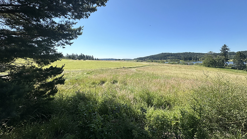
The crux of the opposition appears to be about the mere concept of public walking and biking through San Juan Valley farmland. Land owners value the serenity of farms, and even though those lands are very much open spaces, for them it is still matter of privacy. Perhaps the way some homeowners whose homes are in the island forests and beaches might oppose a trail though their properties.
Some voiced concern that the trails would be used by tourists, and that seemed to increase opposition.
This controversy revealed another question: will San Juan Valley Rd. — or any key roads that radiate out from Friday Harbor — ever be widened if that would require expanded easements? One resident in the meeting said he favored widening the roads to increase safety, but he would not consent to the wider easements that would be needed to relocate ditches and culverts, extend shoulders, and move fences.
San Juan Island draws intelligent, successful people from all over North America. San Juan Island also reveres the citizens whose families go back two, three, and four generations.
One of most unique qualities of San Juan Island is its ability to stay like it used to be…like it was a long time ago.
We have few franchise businesses, other than banks. No stoplights. Few lighted signs on buildings. We preserve old buildings, and if some burn down, we might build them back just as they looked before. We have narrow roads, more like 1944 than 2024. The vistas in the valley look significantly like they did in photographs from 90 years ago.
The island has, however, been able to modernize and change. And more change is in the future.
Few would question that Congressman Larsen did his job by winning $5.28 million for a San Juan County trail.
Maybe, just maybe the County’s planners did their job, too, in working hard to design a trail to one of island’s beautiful lakes in a postcard-like Valley.
And maybe, just maybe landowners did their job in preserving the valley, minimizing potentially heavy foot and bicycle traffic in the agricultural ecosystem.
At least when it comes to a trail; a solar farm may be different. The changes will be discussed and debated each time, each idea on its own unique costs and merits.
Maybe a good trail can be built in another neighborhood in time to leverage $5.28 million in Federal funds.
On this 55-square-mile rock in the middle of the sea, definitions of progress clash. But we’re all in this together. Hopefully always listening, hopefully always learning, hopefully always respecting people doing their jobs.
This CNL2 video is approximately 6 minutes in duration.


